
MT. MARAMI
Maragondon, Cavite
Jump-off point: Brgy. Ramirez, Magallanes, Cavite
Alternate jumpoff: Brgy.Talipusngo, Maragondon, Cavite
LLA: 405 MASL
Days required / Hours to summit: 1-2 days / 4-6 hours
Specs: Minor climb, Difficulty 3/9, Trail class 1-3
Features: Rocky outcrops, scenic views of Cavite
Source: pinoymountaineer.com


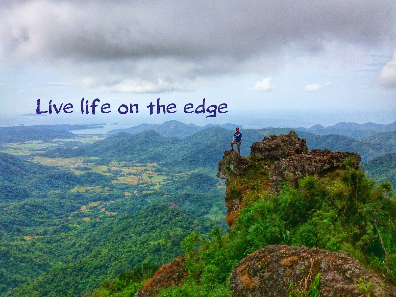
It was a cloudy day when I stepped out of the comfort of our house and went to the bus terminal to embark in another challenging climb. My destination was the so-called twin sister of Pico de Loro, Mt. Marami of Maragondon in Cavite. Mt. Marami is famous for its two big rocky pillars that serves as the summit just like the monolith of Pico de Loro. The famous "Silyang Bato" part of Maragondon awaits to those who want to experience the beauty of the world from the top to down under where you can have a very scenic and life threatening picture.
I was very mesmerized and got excited when I first saw the pictures in the internet. These became my reason to climb this very challenging mountain. I invited my college friends to accompany me with this climb. I told my former classmates that this was a challenging climb. Though, considered as a minor climb. I still allowed them to jump into my journey. Honestly, it was a relief that Kuya Stick joined because I will definitely do not want to go on a hike with the girls if I am the only guy. We kind of started late because some participants were caught up in a traffic jam.
When all the participants arrived, we still have to wait for a couple of minutes before got on board on the bus bound to Maragondon. It was more or less a 3-hour drive from Manila. Then, we took a tricycle going to Brgy. Ramirez. We arrived at their barangay hall where there was a basketball court at the front. I forgot the name of our guide, but he gave us quite an expensive fee. He explained to me that the trail is long, so the fee is expensive. Honestly, I did not believe at first, but I found out that the fee really is nothing compared to the help he gave to us on our way down.
The trail started on a cemented road going to the first river that you need to cross by the name of "Kayrayag River". It was not hard and mostly descending, but I noticed that the trail is very dusty and I believed that the land was made out of clay because of the reddish color. My initial thought was " Thank God, it is not a hot day, but please do not rain" because I knew that these kinds of terrain are extremely muddy and slippery.
 |
| Our team going down the first river crossing |

After the first river crossing, we emerged into an open trail exposed to the direct rays of the sun. Fortunately, our hike was not a sunny one. The trail was wide and the land was dry as seen on the picture below. The shadow of Mt. Marami was still nowhere to be seen. The long road to the summit has just started.

 |
| The lush forest on the side of the trail. |
After few hours of walking, finally the granite peak of Mt. Marami appeared on the horizon. The view of our target destination ignited a flame within me lol. However, our guide quickly told us that it is still very away and we'll probably arrive past noontime because of our moderate pace.


It looks like the mountain was getting nearer as we continued walking through this open area. Afterwards, we went trough the forested trail again passing by another river crossing named "Bangkaan River" as seen below. We passed through this section for about three times and then the ascent started from this point onward.

The trail we used was the "Talahib Trail" which approached Mt. Marami from the south side instead of going straight to it. Just like the name itself, the trail consisted of lots of talahib grass. Some of the grasses were tall and really obscured the trail. This mountain is very notorious for waylaying many hikers and some are indeed getting lost in the labyrinth of trails so one should keep an eye open for the path being undertaken by the guide. Also, this trail is an open area and very hot during summer time.

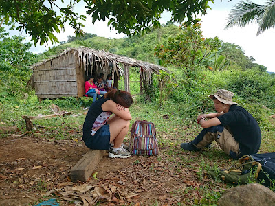
You know you are somehow near when you arrive at the campsite which is marked by a nipa hut as seen below. We took a significant amount of time to rest here. Also, the two grand structure of the peak can now be seen from this point.

 |
| I am contemplating how far we are until the summit lol. |

I already noticed the clouds were already creeping its way. From the campsite, we approached Mt. Marami via a bamboo forest which has a very very confusing trail. We also encountered some cows and saw a slight glimpse of the Pico de Loro and its Parrot Beak. The temperature slowly dropped as more clouds covered the sky. I really hoped back then that the rain would not pour in.
 |
| The two towers of Mt. Marami |
 |
| Some cows can be seen along the trail to the summit |
The clear path to the summit emerged after we're done with the forested area. The view of the granite peak became clearer and lot more magnificent.
 |
| Only few meters more.. |
 |
| Really few meters left. |


The way to the summit is through the middle of those two rocky pillars where one needs to do a short rock bouldering. I assisted them to safely navigate the trail because it was somehow loose but afterwards, you'll be rewarded with the scenic view at the top.
 |
| At the center is Pico de Loro with the Parrot Beak. It is being covered by clouds though. |
 |
| Praying that the clouds clear up so that we can see a better view lol |


It was very windy and cloudier when we arrived at the summit after more or less than 6 hours of trekking. This was really a long hike to the summit. We just chilled at the summit and ate our lunch. Some of us even slept while I went to the famous "Silyang Bato". We descended the summit and went on the other side of for us to reach the famous landmark of this mountain.

There is a gap between those two rocky platforms hidden on the trees which is quite deep so exercise extra caution. The "Silyang Bato" is narrow and can only accommodate one per person. It was very windy at the time I stood up and I did spend lots of there because I was afraid of the sheer height of it. One wrong move and you'll end lots of meters below. The view was really picture perfect. I should have stayed a little bit but I knew that it was only a matter of time before it rain. The journey back to the civilization was really difficult. I could say that this was the most difficult dayhike climb until now because of the trail length, confusing plus super muddy trails. This was the muddiest place that I've been to. We also encountered some inconveniences along the way. We were lost for about 30 minutes which made me really nervous, I tried to be calm on why the hell we're lost. I was the sweeper of our team so honestly I was not paying any attention to our path and suddenly on of us told me that it looks like we're lost. We managed to contact our guide but we cannot point up our exact location so the guide and us panicked. The guide was blaming us for not paying attention to the trail. Honestly, I started to be pissed off and sort of blamed myself. I tried to look for another trail when I encountered another hiker. He told us that the trail that we're located was not the proper way back down and we should go backwards again. I was hesitant to move since I really cannot remember the trail so we just contacted our guide over and over again. He was shouting at the other end of the phone so that we can hear his loud shout and just follow the voice but unfortunately we really cannot hear any loud echo. We moved a bit from our original location and went backwards until we crossed the path of our guide. He told us that it was only a matter of inches. There was big and thick bushes that hides a right path but we didn't noticed it and went straight. I was really pissed and sorry for what happened and just told them to just continue. Our emotions at that time were high until another sort of misfortune happened. It rained and the muddy, slippery and hellish trail appeared that made our descent way too complicated. I started to feel down because this was supposed to be a good climb but it was now turning to be a dangerous climb. When I thought that what we we're experiencing was tough, it suddenly went tougher because one of the participants started to feel dizzy and wobbly and she just cannot continue. I really do not know what to do, I do not have the strength to carry and bring her down. I just gave her lots of encouragement I really saw her struggling in walking. We were so slow that reality kicked in my mind that we could not make it down before sunset. Thankfully, our guide carried her but not all the way down. I also knew that he was already tired as he was carrying her for a significant amount of time. Luckily, a person with a horse passed and we decided to just let her ride the horse since we really cannot bring her down. She went ahead and we were left there walking as usual in thick mud. I slipped a lot and negativity consumed my thoughts. I was just praying that we get back down safely. It was already dark, we have no flashlight and the light from our cellular phones were fading away. We we're trekking under the rain, in the night with only the light from the moon that guided us. My legs we're so damn tired that I nearly gave up until we saw the glimpse of the houses. I was really about to cry I really underestimated the difficulty of this climb but thankfully we all managed to get down this mountain. I really learned a lot from this climb. One should be really prepared when you climb mountains and getting all your team member back safe is really the number one priority. I really admire the courage of my friends who joined me in this climb. I am grateful to our guide for bringing us back although we had a heated argument when we we're lost and of course to the Lord for safely getting us back home.


